Historical Monument status
In 1911, three Neolithic sites at Lake Chalain were given Historical Monument status. This was done at the request of L.A. Girardot, the curator of Lons-le-Saunier Museum and the discoverer of the archaeological sites.
This legal protection, was extended in 1992 to the entire Chalain archaeological reserve through inscription in the Supplement to the Historical Monuments Inventory. The boundaries are the departmental highway to the west, the Doucier beach road to the south, a line 200 meters beyond the 486-meter altitude level toward the interior of the lake, and the water canal to the north.
At Clairvaux, three sites had already been listed as historical monuments:
La Motte-aux-Magnins, Clairvaux III and Clairvaux IV.
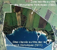
Historical Monuments protection.
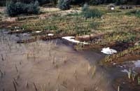
Stabilizing the land around the lake
In 1992, when water level variations were restricted at Lake Chalain, the time had finally come to stabilize the western shore in order to eliminate the effects of erosion. The project was studied and carried out by the Regional Historical Monuments Department in 1995. Biodegradable biotextiles were covered with organic material and held in place with cuttings, plantings and seedlings. These contributed to the development of now-flourishing vegetation that stabilizes the soil under good conditions. Restricted public access to the area and the reduced foot traffic that resulted accelerated the process.
This operation was a real success, and under strict conditions imposed by respect for the archaeological constraints—including the use of a helicopter to bring in transport filling for seeds and plants.

Chalain 2-3.
Example of shore stabilization.
Chalain 3.
Vegetation, eight years later.